
Датотека:Map of Historical Armenia by Britannica 1994.jpg
Већа резолуција није доступна.
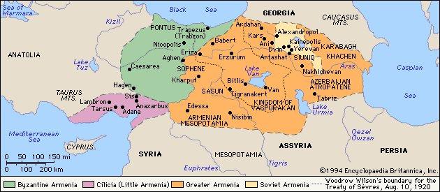
Map_of_Historical_Armenia_by_Britannica_1994.jpg (630 × 275 пиксела, величина датотеке: 46 kB, MIME тип: image/jpeg)
| Ово је датотека са Викимедијине оставе. Информације са њене странице са описом приказане су испод. Викимедијина остава је складиште слободно лиценциралних мултимедијалних датотека. И Ви можете да помогнете. |
| This image comes from the 13th edition of the Encyclopædia Britannica or earlier. The copyrights for that book have expired in the United States because the book was first published in the US with the publication occurring before January 1, 1929. As such, this image is in the public domain in the United States. |  |

|
Ова historical map слика требало би да буду поново израђене као векторска графика у SVG формату. Тиме се остварује неколико предности. Више информација потражите на Commons:Media for cleanup. Ако је ова слика већ доступна у SVG формату, отпремите је. Након отпремања датотеке, овај шаблон замените шаблоном {{vector version available|new image name.svg}}.
|


Историја датотеке
Кликните на датум/време да бисте видели тадашњу верзију датотеке.
| Датум/време | Минијатура | Димензије | Корисник | Коментар | |
|---|---|---|---|---|---|
| тренутна | 16:18, 8. новембар 2009. | | 630 × 275 (46 kB) | Elegant's | {{Information |Description={{en|1=Map of Historical Armenia by Britannica 1994}} |Source=[http://www.cilicia.com/pics/picf/vahan/MapofArmenia.jpg cilicia.com] |Author=Encyclopædia Britannica |Date=1994 |Permission= |other_versions= }} |
Употреба датотеке
Следећа страница користи ову датотеку:
Глобална употреба датотеке
Други викији који користе ову датотеку:
- Употреба на ar.wikipedia.org
- Употреба на az.wikipedia.org
- Употреба на ba.wikipedia.org
- Употреба на be.wikipedia.org
- Употреба на bg.wikipedia.org
- Употреба на de.wikipedia.org
- Употреба на en.wikipedia.org
- Употреба на hy.wikipedia.org
- Употреба на pt.wikipedia.org
- Употреба на ru.wikipedia.org
- Употреба на uk.wikipedia.org
- Употреба на uz.wikipedia.org