
Датотека:2022 Russian invasion of Ukraine.svg

Originalna datoteka (SVG datoteka, nominalno 2.199 × 1.478 piksela, veličina: 3,73 MB)
| Ovo je datoteka sa Vikimedijine ostave. Informacije sa njene stranice sa opisom prikazane su ispod. Vikimedijina ostava je skladište slobodno licenciralnih multimedijalnih datoteka. I Vi možete da pomognete. |
Rules for editing the map
|
| All edit warring, adding of unsourced information or performing a color change without consensus may result in the user being blocked. All contributions should first be discussed on the talk page. |
Opis izmene

|
This file may be updated to reflect new information. If you wish to use a specific version of the file without new updates being mirrored, please upload the required version as a separate file. |
| Opis | |||
| Datum | 24. februar 2022. (first version) | ||
| Izvor |
Own work based on: Russo-Ukrainian conflict (2014-2022).svg by Rr016 & Ukraine adm location map improved.svg by Yakiv Gluck
|
||
| Autor | Viewsridge | ||
| Ostale verzije |
[]
|
||
| SVG genesis | This map is translated using SVG switch elements: all translations are stored in the same file.
|


.gif)

.gif)


_en.png)
_vi.png)
_ru.png)
.svg)
This file is translated using SVG <switch> elements. All translations are stored in the same file! Learn more.
For most Wikipedia projects, you can embed the file normally (without a To translate the text into your language, you can use the SVG Translate tool. Alternatively, you can download the file to your computer, add your translations using whatever software you're familiar with, and re-upload it with the same name. You will find help in Graphics Lab if you're not sure how to do this. |
Licenciranje
- Dozvoljeno je:
- da delite – da umnožavate, raspodeljujete i prenosite delo
- da prerađujete – da preradite delo
- Pod sledećim uslovima:
- autorstvo – Morate da date odgovarajuće zasluge, obezbedite vezu ka licenci i naznačite da li su izmene napravljene. Možete to uraditi na bilo koji razuman manir, ali ne na način koji predlaže da licencator odobrava vas ili vaše korišćenje.
- deliti pod istim uslovima – Ako izmenite, preobrazite ili dogradite ovaj materijal, morate podeliti svoje doprinose pod istom ili kompatibilnom licencom kao original.
Istorija datoteke
Kliknite na datum/vreme da biste videli tadašnju verziju datoteke.
| Datum/vreme | Minijatura | Dimenzije | Korisnik | Komentar | |
|---|---|---|---|---|---|
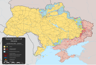
| trenutna | 09:11, 27. maj 2024. | | 2.199 × 1.478 (3,73 MB) | Physeters | clean up; for future reference, only the red shaded areas on the ISW map are shown as Russian controlled on this map |
| 11:14, 26. maj 2024. |  | 2.199 × 1.478 (3,72 MB) | Hoben7599 | Per ISW | |
| 13:16, 22. maj 2024. |  | 2.199 × 1.478 (3,32 MB) | Hoben7599 | File uploaded using svgtranslate tool (https://svgtranslate.toolforge.org/). Added translation for zh-hant. | |
| 07:49, 21. maj 2024. |  | 2.199 × 1.478 (3,72 MB) | Physeters | Updates per the ISW, update Staromaiorske, Klishshchiivka, and Robotyne per the detailed map | |
| 06:00, 18. maj 2024. |  | 2.199 × 1.478 (3,72 MB) | Physeters | Fix Bohudukhiv | |
| 22:47, 16. maj 2024. |  | 2.199 × 1.478 (3,72 MB) | Physeters | Updates in Kharkiv Oblast per the ISW | |
| 06:40, 14. maj 2024. |  | 2.199 × 1.478 (3,72 MB) | Physeters | fix Derhachi | |
| 07:36, 13. maj 2024. |  | 2.199 × 1.478 (3,72 MB) | Alexiscoutinho | Updated Vovchansk per detailed map | |
| 04:49, 13. maj 2024. |  | 2.199 × 1.478 (3,72 MB) | Physeters | Updates per the ISW; for future reference, sources (like SuriyakMaps) must first have their reliability vetted on the talk page before they can be used to update the map; at the moment, the only two verified sources are the ISW and the Detailed Map on Wikipedia | |
| 12:34, 12. maj 2024. |  | 2.199 × 1.478 (3,31 MB) | BlackShadowG | File uploaded using svgtranslate tool (https://svgtranslate.toolforge.org/). Added translation for zh-tw. |
Upotreba datoteke
2 sledeće stranice koriste ovu datoteku:
Globalna upotreba datoteke
Drugi vikiji koji koriste ovu datoteku:
- Upotreba na af.wikipedia.org
- Upotreba na als.wikipedia.org
- Upotreba na am.wikipedia.org
- Upotreba na ang.wikipedia.org
- Upotreba na an.wikipedia.org
- Upotreba na ar.wikipedia.org
- Upotreba na ary.wikipedia.org
- Upotreba na arz.wikipedia.org
- Upotreba na ast.wikipedia.org
- Upotreba na azb.wikipedia.org
- Upotreba na az.wikipedia.org
- Upotreba na bat-smg.wikipedia.org
- Upotreba na bcl.wikipedia.org
- Upotreba na be-tarask.wikipedia.org
- Upotreba na be.wikipedia.org
- Upotreba na bg.wikipedia.org
- Upotreba na bh.wikipedia.org
- Upotreba na bn.wikipedia.org
- Upotreba na br.wikipedia.org
- Upotreba na bs.wikipedia.org
- Upotreba na bxr.wikipedia.org
Još globalnog korišćenja ove datoteke.