
Датотека:USA territorial growth.gif

Veličina ovog prikaza: 800 × 498 piksela. 3 druge rezolucije: 320 × 199 piksela | 640 × 398 piksela | 921 × 573 piksela.
Originalna datoteka (921 × 573 piksela, veličina datoteke: 2,01 MB, MIME tip: image/gif, petlja, 10 kadrova, 50 s)
| Ovo je datoteka sa Vikimedijine ostave. Informacije sa njene stranice sa opisom prikazane su ispod. Vikimedijina ostava je skladište slobodno licenciralnih multimedijalnih datoteka. I Vi možete da pomognete. |
Opis izmene
| Opis |
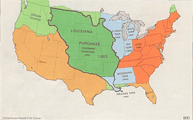
English: US territorial growth 1810–1920, based on the PD USGS maps in Category:Territorial growth maps of the United States.
See key below for explanation of colors.  |
||||||
| Izvor |
|
||||||
| Autor |
|
||||||
| Ostale verzije |
|

Licenciranje
This image is in the public domain in the United States because it only contains materials that originally came from the United States Geological Survey, an agency of the United States Department of the Interior. For more information, see the official USGS copyright policy.
|
Istorija datoteke
Kliknite na datum/vreme da biste videli tadašnju verziju datoteke.
| Datum/vreme | Minijatura | Dimenzije | Korisnik | Komentar | |
|---|---|---|---|---|---|
| trenutna | 03:39, 31. maj 2006. | | 921 × 573 (2,01 MB) | Roke~commonswiki | longer interval, 3 seconds --> 5 seconds |
| 14:21, 30. maj 2006. |  | 921 × 573 (2,67 MB) | Roke~commonswiki | US territorial growth 1810-1920, based on the USGS maps in commons:Category:USA Territorial Growth Maps, put together in Corel Painter IX. The individual maps have this licence: {{PD-USGov-USGS}} If it is necessary for me to licence my contributio |
Upotreba datoteke
2 sledeće stranice koriste ovu datoteku:
Globalna upotreba datoteke
Drugi vikiji koji koriste ovu datoteku:
- Upotreba na bn.wikipedia.org
- Upotreba na en.wikipedia.org
- Upotreba na es.wikipedia.org
- Upotreba na fa.wikipedia.org
- Upotreba na fy.wikipedia.org
- Upotreba na ha.wikipedia.org
- Upotreba na he.wikipedia.org
- Upotreba na nl.wikipedia.org
- Upotreba na pnb.wikipedia.org
- Upotreba na ru.wikipedia.org
- Upotreba na ru.wikinews.org
- Upotreba na tr.wikipedia.org
- Upotreba na ur.wikipedia.org
- Upotreba na uz.wikipedia.org
- Upotreba na www.wikidata.org