
Датотека:RedArmy19Aug31Dec44.jpg
Величина овог приказа: 788 × 600 пиксела. 4 друге резолуције: 315 × 240 пиксела | 631 × 480 пиксела | 1.009 × 768 пиксела | 1.256 × 956 пиксела.
Оригинална датотека (1.256 × 956 пиксела, величина датотеке: 531 kB, MIME тип: image/jpeg)
| Ово је датотека са Викимедијине оставе. Информације са њене странице са описом приказане су испод. Викимедијина остава је складиште слободно лиценциралних мултимедијалних датотека. И Ви можете да помогнете. |
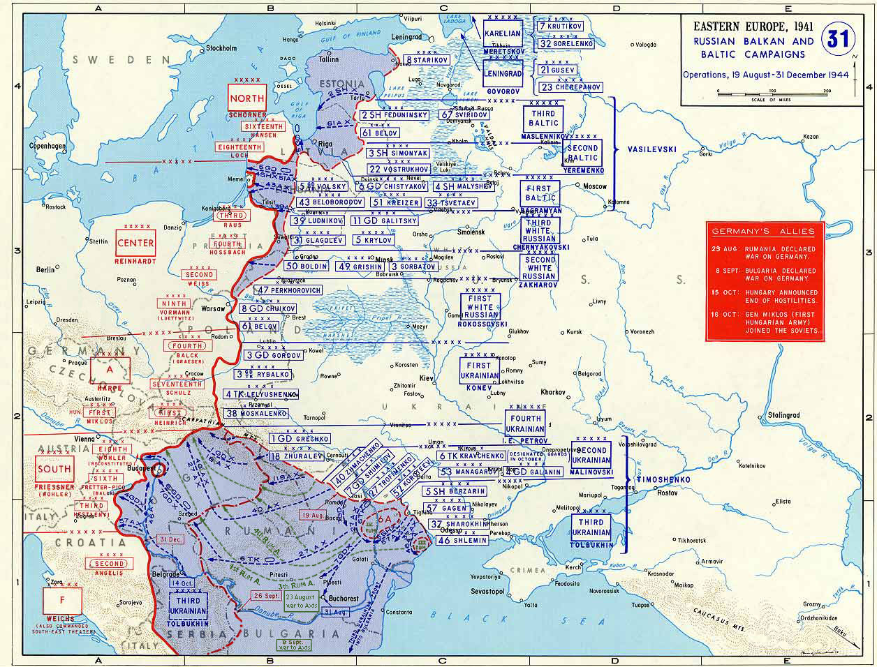
Taken from the campaign series, made public by the US-Army under www.dean.usma.edu The picture is public domain. It shows the situation of the Easter Front from 13. Aug. '44 until 31. Dec. '44
- Source: dean.usma.edu archive copy at the Wayback Machine
From website:
- In 1938 the predecessors of what is today The Department of History at the United States Military Academy began developing a series of campaign atlases to aid in teaching cadets a course entitled, "History of the Military Art." Since then, the Department has produced over six atlases and more than one thousand maps, encompassing not only America’s wars but global conflicts as well.
- In keeping abreast with today's technology, the Department of History is providing these maps on the internet as part of the department's outreach program. The maps were created by the United States Military Academy’s Department of History and are the digital versions from the atlases printed by the United States Defense Printing Agency. We gratefully acknowledge the accomplishments of the department's former cartographer, Mr. Edward J. Krasnoborski, along with the works of our present cartographer, Mr. Frank Martini.
- Please be aware that these maps are large in file size and may require substantial download times.
Ова датотека је рад припадника Америчке војске или особе запослене у њој и начињена је за време обављања дужности те особе. Као рад америчке савезне владе, ова датотека је у јавном власништву у САД-у.
|
 |

|
Ова map слика требало би да буду поново израђене као векторска графика у SVG формату. Тиме се остварује неколико предности. Више информација потражите на Commons:Media for cleanup. Ако је ова слика већ доступна у SVG формату, отпремите је. Након отпремања датотеке, овај шаблон замените шаблоном {{vector version available|new image name.svg}}.
|


Историја датотеке
Кликните на датум/време да бисте видели тадашњу верзију датотеке.
| Датум/време | Минијатура | Димензије | Корисник | Коментар | |
|---|---|---|---|---|---|
| тренутна | 20:47, 12. јануар 2015. | | 1.256 × 956 (531 kB) | Spiridon Ion Cepleanu | Borders of years 1940-1944 (rectified some little mistakes) |
| 12:52, 22. април 2007. |  | 1.256 × 956 (203 kB) | Nasiruddin | Taken from the campaign series, made public by the US-Army under www.dean.usma.edu The picture is public domain. It shows the situation of the Easter Front from 13. Aug. '44 until 31. Dec. '44 *Source: [http://www.dean.usma.edu/history/web03/atlases/grea |
Употреба датотеке
3 следеће странице користе ову датотеку:
Глобална употреба датотеке
Други викији који користе ову датотеку:
- Употреба на ar.wikipedia.org
- Употреба на ca.wikipedia.org
- Употреба на cs.wikipedia.org
- Употреба на de.wikipedia.org
- Употреба на el.wikipedia.org
- Употреба на en.wikipedia.org
- Употреба на es.wikipedia.org
- Употреба на et.wikipedia.org
- Употреба на fr.wikipedia.org
- Употреба на he.wikipedia.org
- Употреба на id.wikipedia.org
- Употреба на it.wikipedia.org
- Употреба на ja.wikipedia.org
- Употреба на nl.wikipedia.org
- Употреба на pl.wikipedia.org
- Употреба на pnb.wikipedia.org
- Употреба на ro.wikipedia.org
- Употреба на ru.wikipedia.org
- Употреба на sh.wikipedia.org
- Употреба на tr.wikipedia.org
Још глобалног коришћења ове датотеке.